Driest monsoons in 1,000 years warn of catastrophe
May 14, 2011 — andyextance

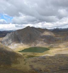
Sediment at the bottom of Laguna Pumacocha in the Peruvian Andes, shown here, provided a unique insight into rainfall in the area over the past 2000 years. Credit: University of Pittsburgh
Summer monsoons in the Andes have reached their driest in around 1,000 years as the world has warmed in recent decades, a rainfall record retrieved by US scientists has shown. With the region’s glaciers also retreating thanks to climate change, if this trend continues, it will severely threaten local populations’ water supplies, explains Don Rodbell from Union College, New York. “There have been large natural fluctuations in the amount of rainfall in the high Andes,” he explained. “Were they to happen again in the future, which they almost certainly will, they will provide a really potentially catastrophic impact on people who live at the margins. It’s hard to avoid imagining a scenario where the glaciers are gone or much reduced in extent, and then with a drought like we’ve seen in this record, you’ve really hit them with a double whammy.”
The rainfall record in question is a 6 foot long cylinder of sediment drilled from the bottom of Laguna Pumacocha in the Peruvian Andes. Broxton Bird, lead author on the Proceedings of the National Academy of Sciences of the USA paper unveiling the secrets the sediment contains, chose that lake during his PhD work at the University of Pittsburgh. Bird, who’s currently on a five month field trip in Tibet, co-designed the study that unlocked the information it held with Rodbell. The unusual conditions at Laguna Pumacocha allowed Rodbell, Bird, and his Pittsburgh colleagues to look back at the monsoons that occur each summer in the Andes in unprecedented detail. “A lot of it was dumb luck,” Rodbell admitted.
Untouched by critters

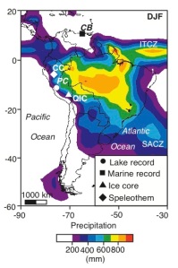
The study compared the record in the Pumacocha sediment core (PC) to various geological records from South America—Cascayunga Cave (CC), the Quelccaya ice Cap (QIC), and the Cariaco Basin (CB)—as well as the annual position of the Intertropical Convergence Zone (ITCZ). Regions with precipitation above 200 mm during the austral summer (December–February) are coloured. Study codesigner Don Robell warns that populations on the western coast of South America could be severely affected as monsoons get drier and glaciers shrink. Credit: University of Pittsburgh
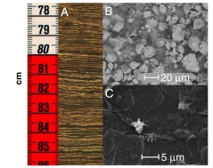
Laguna Pumacocha holds such high concentrations of a chemical called calcium carbonate that it is forced – or precipitated – out of the water as the mineral calcite. “That is probably the most important kind of record you can get out of these lakes,” Rodbell said. The information contained in that record is especially good quality as the bottom of the lake is “anoxic”. “That means no oxygen around, no critters down there to mix things up and mess it up,” the Union College professor explained. “Without the mixing effect the lake was precipitating layer on layer on an annual basis, so we can actually count our way back in this record, layer by layer, to nearly 2,000 years ago.” These layers – called varves – allow year-by-year analysis in much the same way as tree rings do. “Having a varved lake is very rare, but it’s not just us telling everybody it’s a varved record, we’ve actually been able to prove that.”
Calcite is an important record because it contains oxygen that has come from water entering the lake from monsoon rains and snows. There are naturally two types – or isotopes – of oxygen atoms, one slightly heavier than the other. Usually, the amount of each isotope in the water of the lake depends on the amount of rain and snow that falls and how much water evaporates. However, the amount of water that collects in the Andes around Pumacocha each year is more than the lake can contain. This means that water does not remain in the lake for long enough for evaporation to have a significant effect. Consequently, the relationship between oxygen isotopes in the calcite varves depositing at the lake bottom is an almost direct link to the amount of monsoon rain that fell in a given year.
Starving the monsoon

Sediments from the Pumacocha core, where A) shows a digital camera photograph of millimetre scale varves in the upper part of the core, B) shows calcite crystals thousandths of a millimetre, or micrometres (µm) in size and C) shows even smaller organic material found in the core. Credit: PNAS
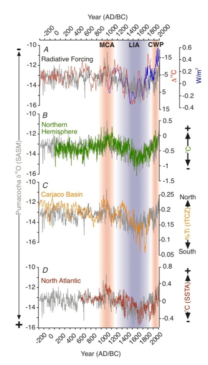
Interpreting the record showed a strong relationship between rainfall at Pumacocha and reconstructed temperature records over the past 2000 years – with rainfall decreasing as temperature rises. The driest period occurred between 935 and 950 AD and 1000 and 1040 AD, during a warm period known as the Medieval Climate Anomaly (MCA) or Medieval Warm Period (MWP). However, rainfall at Pumacocha in recent decades has reached its lowest level since then, which is consistent with records from the Amazon basin. The predicted effects of climate change are often summarised as the world becoming warmer and wetter, which would seem to contradict the drying in the Andes. Rodbell notes, however, that while temperatures rise relatively evenly across the planet, rainfall effects are more regional.
“Rainfall patterns that involve large scale things like the South American summer monsoon, those are much harder to predict,” Rodbell said. “You could get areas that get wetter, and the globe on average may get wetter and warmer, but there may be some areas, and we think the Andes may be one, where it doesn’t get wetter, it actually gets drier.” The explanation for the drying in the Andes, the researchers suggest, comes from a weather system called the Intertropical Convergence Zone (ITCZ) – better known as the Doldrums – that feeds moisture to the South American monsoons. As temperatures rise, the convergence zone moves northward, and the intensity of the monsoons decrease. Continued Northern Hemisphere and North Atlantic warming may therefore reduce monsoon rainfall even further, Rodbell warned. “In that case it’s a real concern for the population that lives up in the high Andes, and even in the city of Lima, and the millions and millions of people down on the coast who rely on the runoff from the glaciers and the water supplies coming in from the Andes.”

Four different climate measures superimposed over the rainfall measure retrieved from oxygen isotopes in calcite precipitated from Laguna Pumacocha (δ18Ocal, grey line). (A) Reconstruction of the net energy flow into the Earth, known as radiative forcing (blue) for the last 1,000 years and residues of the 14C carbon isotope that is a proxy for solar variability for the last 2,300 years. (B) reconstructed Northern Hemisphere temperatures, (C) Percentage titanium content (%Ti) from the Cariaco Basin, Venezuela, interpreted as a proxy for the location of the ITCZ, and (D) reconstructed sea surface temperature anomalies (SSTA) in the North Atlantic.
Comments (0)
You don't have permission to comment on this page.